Theme of Spring 2026: Flood damage
2nd worst flood in the past 50 years
The defining story of spring 2026 is the damage from winter flooding. The Washington Cascades were battered by one atmospheric river after another rolling in from the South Pacific - seven of them between October 19th and November 13th alone. An almost record-setting storm peaked the night of December 10th and was immediately followed by another large system, then another on January 12th, and a final large one on March 20th.
As bad as this year was, 2006 was roughly 3x worse by volume, whether measured monthly, daily, or in 4-day blocks. November 7th, 2006 still holds the 50-year record for one-day rainfall. This year's PCT-related damage was especially severe west of Glacier Peak, and much of it remains un-repaired.
PCT Access Roads
There are many ways to access the PCT. Listed below are the most ones, ordered north to south.
North Cascades Highway (SR-20) to Rainy Pass
SR-20 reopened June 14th after crews repaired multiple sections of winter damage between MP 143 and 148.
On June 2nd, the rockslide at milepost 131 was cleared and the west-side closure moved back to the regular winter gate at MP 134. Before that, the east-side closure had shifted to MP 156 while crews cleared damage east of Rainy Pass, then moved to MP 134 (1.5 miles west of Rainy Pass) so Rainy Pass could be reached from the east.
This road intersects the PCT at Rainy Pass, mm 2594.4
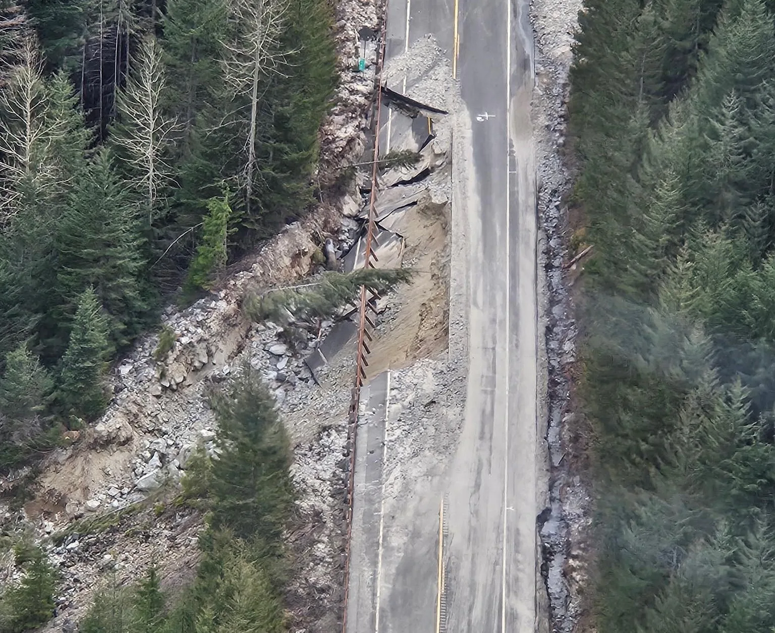
Harts Pass Road
This road reopened on June 24th, 2026, and is now smooth like Barry White.
On March 26th, the US Forest Service closed Harts Pass Road, starting at Monument Creek Trailhead, for repairs to winter flood damage.
Harts Pass is a hair-raising 12.28-mile gravel road with no guardrails or downhill shoulder. It's the northernmost PCT access point, intersecting the trail at mm 2625.3
Section K
Stehekin Valley Road
This road is open and the shuttle bus is running its normal schedule.
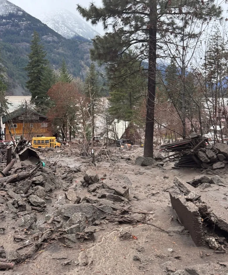
December's rains caused Purple Creek to flood, washing out a section of Stehekin Valley Road and destroying the wastewater treatment plant that serves the Landing, North Cascades Lodge, and NPS facilities. The lodge will not open this year, but the Post Office is open. Government assistance is expected to prioritize this repair. There was also significant damage to Company Creek Road (on the opposite side of the Stehekin River), which doesn't directly affect PCT hikers; repair work there has already begun.
This road intersects the PCT at High Bridge, mm 2575.1. It runs 11 miles between bus stops.
Railroad Creek to Holden Village
block
CLOSED, likely for all of the 2026 season. More than 11 landslides on Railroad Creek Road have shut down Lucerne and Holden entirely.
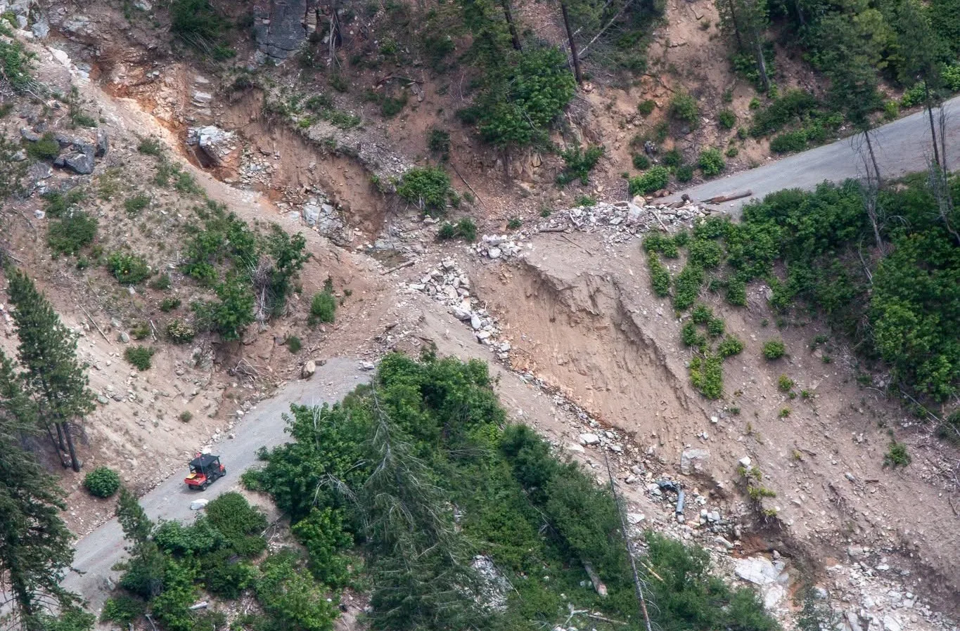 Normally, this route is a ferry ride to Lucerne followed by a bus ride to Holden Village,
then a 10-mile hike over Cloudy Pass to intersect the PCT north of Suiattle Pass at mm 2556
FR-26 to Suiattle River Trailhead (aka Sulphur Mtn Trailhead)
block
CLOSED at milepost 4 (20 miles from the trailhead) with 6 major washouts. No repairs are underway; the USFS is optimistic about restoring access up to mp 10.5 this year, but not beyond for some time. Walking this road involves extremely challenging obstacles.
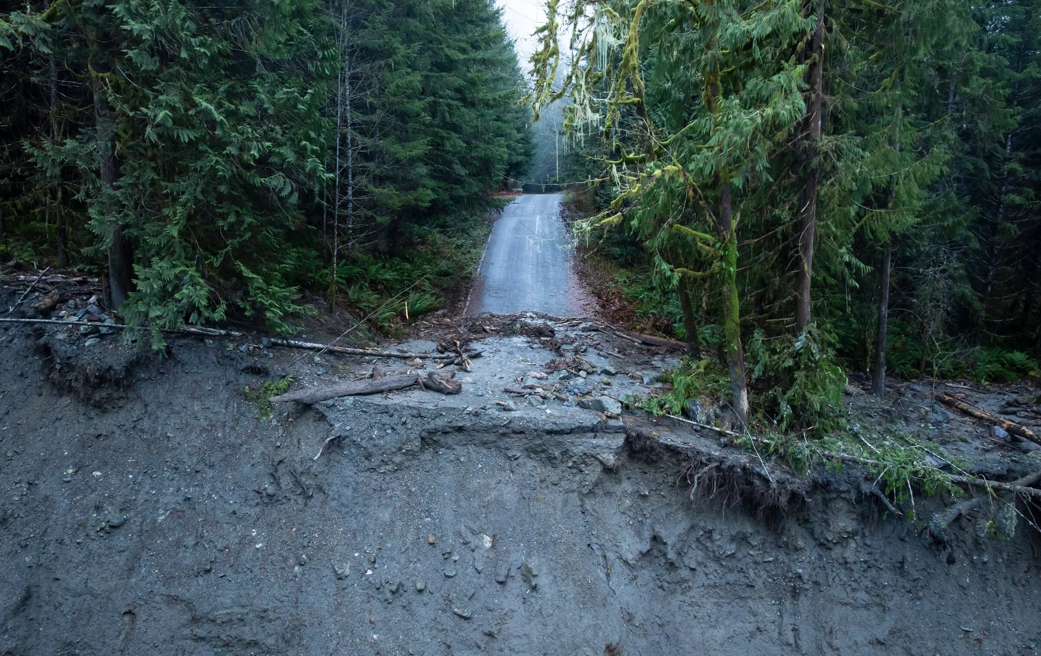 Normally, this is a 22.6-mile drive from State Route 530,
then a 6.46-mile hike on Suiattle River Trail #784 to intersect the PCT just north of the Suiattle River Bridge, mm 2544.
FR-49 to North Fork Sauk River Trailhead
The Sloan Creek Road is open but rough. It's currently the ONLY OPTION for accessing the middle of Section K from the west.
From the Mountain Loop Highway, it's 6.71 miles of dirt road,
then an 8.66-mile hike on North Fork Sauk River Trail #649 to intersect the PCT just north of White Pass Camp, mm 2505.7
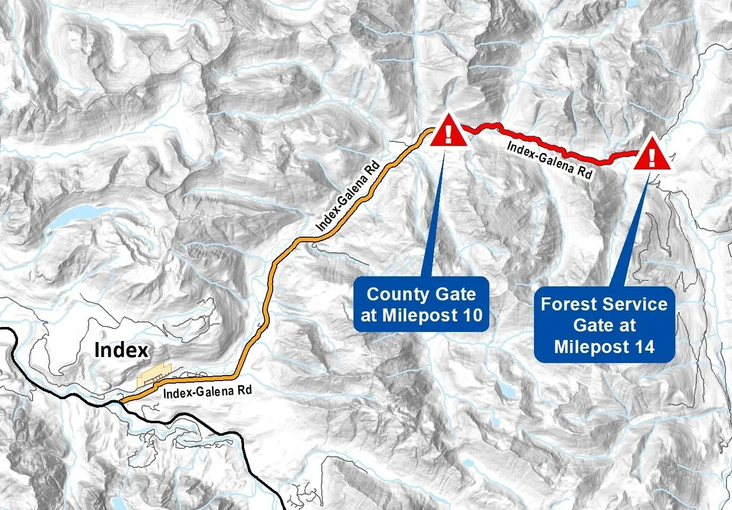
FR-63 (Index-Galena Road) to North Fork Skykomish Trailhead [From US-2]
block
CLOSED, with a washout and a missing bridge. FR-65 can be used to reach Jack Pass (MP 14), but no further.
This road was closed for 17 years until it was rebuilt and reopened in November 2023.
FR-65 to Little Wenatchee Ford Trailhead (the OTHER FR-65)
7/21 Update: Trail reports say its open. FS website still says it's closed 2.7-miles from the trailhead.
Chiwawa River Road to Trinity Trailhead
block Confirmed GATED at Atkinson Flat Campground, 5.5 miles from Trinity Trailhead.
FR-67 (Rainy Creek Road) to Smithbrook Trailhead
Open but rough to Smithbrook. The rest of FR-67 beyond is closed due to flood damage. This is a 2.72-mile road,
followed by a 1.23-mile hike to intersect the PCT at Union Gap, mm 2475
Section J
There are no access road closures for Section J. That includes:
US Route 2 to Stevens Pass
This paved highway intersects the PCT at Stevens Pass, mm 2467.3
FR-6095 to Tunnel Creek Trailhead [From US-2]
1.27 miles of dirt road from US-2,
then a 1.35-mile hike to intersect the PCT at Hope Lake, mm 2459.2
FR-840 to Surprise Creek Trailhead [From US-2]
0.33 miles of dirt road from US-2,
then a 3.7-mile hike to intersect the PCT at Surprise Lake, mm 2453.8
Cle Elum Valley Road to Tucquala Meadows Trailhead [From I-90]
12.4 miles of dirt road,
then a 4.55-mile hike to intersect the PCT at Deception Pass, mm 2446
Cle Elum Valley Road to Cathedral Pass Trailhead [From I-90]
12.2 miles of dirt road,
then a 4-mile hike to intersect the PCT at Cathedral Pass, mm 2441
Salmon La Sac Trailhead
0.7 miles of dirt road,
then a 6.2-mile hike to intersect the PCT at Waptus Lake, mm 2434
Cooper Road to Pete Lake Trailhead [From I-90]
1.75 miles of dirt road,
then a 6.2-mile hike to intersect the PCT near Lemah Creek, mm 2417
Section I
There are no access road closures for Section I. That includes:
Interstate 90 to Snoqualmie Pass
This eight-lane highway intersects the PCT at Snoqualmie Pass, mm 2396.4
FR-54 to Stampede Pass and Tacoma Pass [From I-90 exit 52]
3.5 miles of dirt road to Stampede Pass; 8.54 miles of dirt road to Tacoma Pass.
This road intersects the PCT at Stampede Pass, mm 2378.1
NF-7000 to Naches Pass [From SR-410]
After leaving Hwy 410, it's 4.58 miles paved, then 11.5 miles of dirt road,
followed by a half-mile walk to intersect the PCT near the Mike Urich Cabin, mm 2350.1
Crystal Mountain Boulevard [From SR-410]
There are multiple ways to hike to the PCT from Crystal:
- From Halfmile Camp Trailhead, it's a 4.48-mile hike to the PCT at Norse Peak.
- From Crystal to Bullion Basin (mm 2334.3), it's only a 2.21-mile hike.
- From Crystal to Bear Gap, it's a 2.06-mile hike (3.04 miles from the top of the gondola).
SR-410 to Chinook Pass
Chinook Pass and Highway 123, connecting Chinook Pass and Packwood, reopened on May 22nd, 2026 after the usual winter closure. This paved road intersects the PCT at mm 2326.8
Section H
There are no access road closures for Section H. That includes:
State Route 12 to White Pass
This two-lane highway does not close for winter. This road intersects the PCT at mm 2298.1
Chambers Lake Road to Snowgrass Trailhead
16.3 miles of dirt road,
then a 4.57-mile hike on Snowgrass Trail #96 to intersect the PCT at Snowgrass Bypass, mm 2277
FR-21 to Walupt Lake Road [From Highway 12]
Freshly graded this spring. 20.7 miles of dirt road,
then a 4.26-mile hike on Walupt Lake Trail to intersect the PCT at mm 2268
FR-2329 to Midway
23.64 miles of dirt road.
This road intersects the PCT at mm 2256.2
FR 5603 to Potato Hill
30.75 miles of dirt road.
This road intersects the PCT at mm 2254.3
FR-23 north to Williams Mine (Mt Adams) from Trout Lake
This road intersects the PCT at mm 2232.1
FR-65 to Panther Creek Campground from Wind River Highway
This paved road intersects the PCT at mm 2185.2