Native tribes on both sides of the Cascade range were constantly crossing to trade, hunt, and gather alpine plants. Every few years area tribes would gather at a spot on the Yakima River near what is today Exit 101 on Interstate 90 and western tribes would cross the mountains to attend. Natives had been crossing the Cascade range for thousands of years and were aware of the best routes to get to and from the Yakima River valley including Snoqualmie Pass (3,044 ft), Yakima Pass (3,596 ft), Meadow Pass (3,668 ft), Stampede Pass (3,718 ft), Tacoma Pass (3,480 ft), and Naches Pass (4,930 ft).
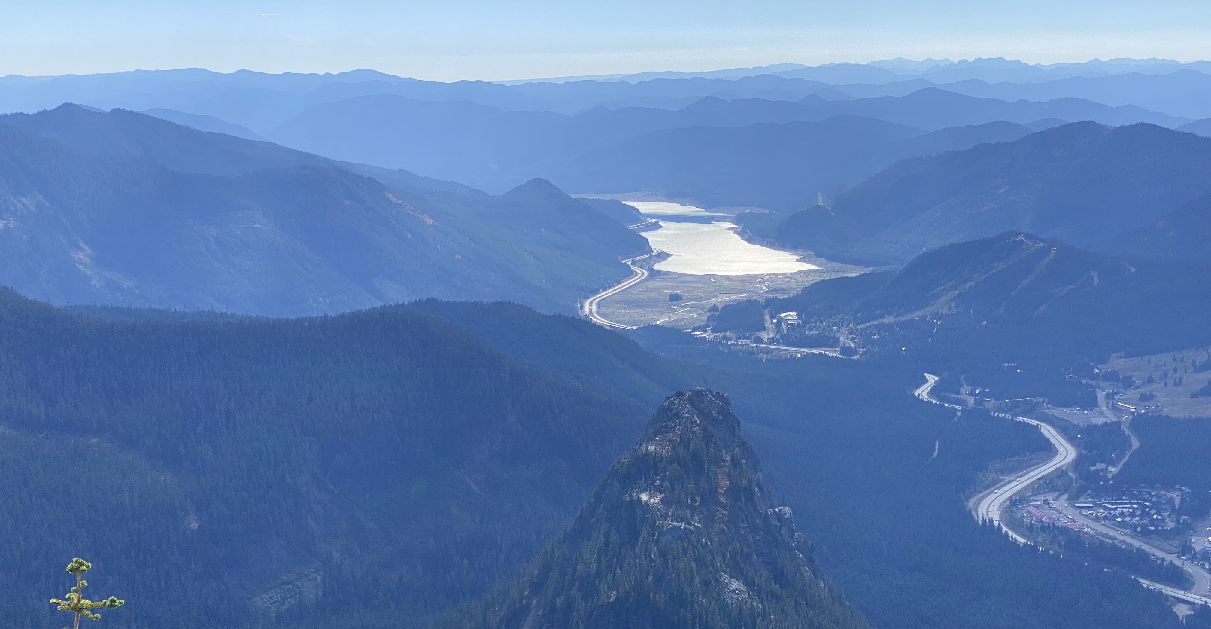
Generally, the lowest route is the easiest to travel, but each of these passes has its own set of obstacles. While Snoqualmie Pass is the lowest route, its primary obstacle is steep rock walls that plunge directly into both sides of Lake Keechelus at its middle. If you drive Interstate 90 today you will see work crews still working on this obstacle just as they did to initially connect the route with a wagon road. Snoqualmie Pass also involves the hairpin turn to make the transition from the east and west valleys which are almost parallel to each other (Coal Creek and Commonwealth Creek).

To heavily over-simplify the facts in summary; the natives knew that Snoqualmie Pass was the best route if you were walking (you could canoe across Keechelus Lake or walk the narrow trail on the east bank), and Yakima Pass (one mile south of Mirror Lake on the PCT, and 6.3 miles south of Snoqualmie Pass in a straight line) was the best route if you were on horseback and needed a wider trail. We know that for at least 20 years whites were calling both routes "Snoqualmie Pass" which caused significant confusion.
There was great desire to establish an overland route across the Cascade range to/from Puget Sound on the part of the Secretary of War Jefferson Davis, the US Congress who authorized project funds, Washington Territory Governor Issac Stevens, The Hudson's Bay Company, and the merchants of the Puget Sound towns. The goal was a route that would accommodate both wagon road and railroad.
Captain George McClellan
Captain George McClellan sailed from the east coast to Fort Vancouver at the mouth of the Columbia River arriving late June 1853. A month later he departed with 65 men, 100 horses, and the latest scientific survey instruments. We know his first trip over the Cascades took him south of Mt St Helens (natives informed him that the mountain had erupted 11 years earlier) and north of Mt Adams. After scouting Naches Pass from the east and declaring it an unusable route, he left from near Ellensburg with 9 men to seek out Snoqualmie Pass on September 4th, 1853. Near Thorp they encountered a native who agreed to guide them for pay. Today the road is on the north side of Lost Lake, but they seem to have gone on the south side and had to walk their horses because the trail was so steep. On Wednesday September 7th, the air hazy with smoke from a forest fire, they went over Yakima Pass, thinking it was Snoqualmie Pass, and explored about three miles down the west side, deciding the route was too steep for a wagon road. The natives told McClellan that there was another route north of there, but he chose not to explore it. In his report to Governor Stevens, he did write of a foot trail leading from the head of Lake Keechelus to the head of the South Fork Snoqualmie River. He wrote that Indians represented it as "seldom used and passable only by an active unencumbered man."
Lieutenant Abiel Tinkham
After speaking with settlers on the west side, Governor Stevens gained a better understanding of routes over the Cascades and, unsatisfied with McClellan’s assessment, sent a letter from Olympia to Fort Walla Walla which took two weeks to get there. The letter was for Lieutenant Abiel Tinkham who was crossing the Rocky Mountains and was expected to report in at the fort. Abiel, a native of Maine, had performed outstanding exploits at fearlessly tackling three known crossings of the Rocky Mountains in late fall weather. Despite a harrowing mountain crossing on self-made snowshoes, he did manage to make his way to the fort arriving on January 1st, one day after the letter.
In the letter the Governor asked Tinkham to make a winter crossing of the Cascades via Lake Keechelus and personally evaluate the route to the South Fork Snoqualmie River. The letter also gave advice on who and what to bring along which Tinkham ignored. Instead, Tinkham chose no white men to accompany him, and to bring no cattle for food. He took only one fresh horse from the fort and headed out with three Walla Walla Indian guides. On January 7th, 1854 they swam across the Columbia River.
That same day McClellan, leading a new party, was hiking up around Snoqualmie Falls. The Governor had instructed him to make another attempt from the west. A day or two later he was stopped by snow at Cedar Falls, above Rattlesnake Lake. He had come unprepared for snow and turned back. He did realize then, that Yakima Pass, where he had been heading, was not Snoqualmie Pass, but again chose not to explore that route.
At Union Gap Tinkham dismissed his Walla Walla guides and hired two Yakima guides who took him to a camp near today's Roslyn. Tinkham reported seeing thousands of Indian horses grazing along the way. There he spent a night in a lodge and hired three more Cle Elum guides. He sent one guide to take his horse back to Walla Walla and continued on foot the rest of the way. He chose not to bring a tent to reduce pack weight.
On January 20th he and four native guides camped at the south end of Lake Keechelus. It snowed 18" that night making the total snow depth 6'-7'. The next day progress was slow in the soft fresh snow. They snowshoed the west side of Lake Keechelus, up Roaring Creek, and simply walked across frozen Lost Lake to Yakima Pass and down the Cedar River. The depth of the snow decreased rapidly as they descended the west side of the pass. At the NW end of Cedar Lake (near Rattlesnake Lake) they cached their snowshoes for the return trip (which I am not sure they ever made). After camping with Indians near today's Fall City, on January 27th, 1854 Abiel Tinkham arrived at Elliott Bay and Seattle. It's unclear to me if Tinkham intended to take Yakima Pass or if he made the same mistake McClellan made.
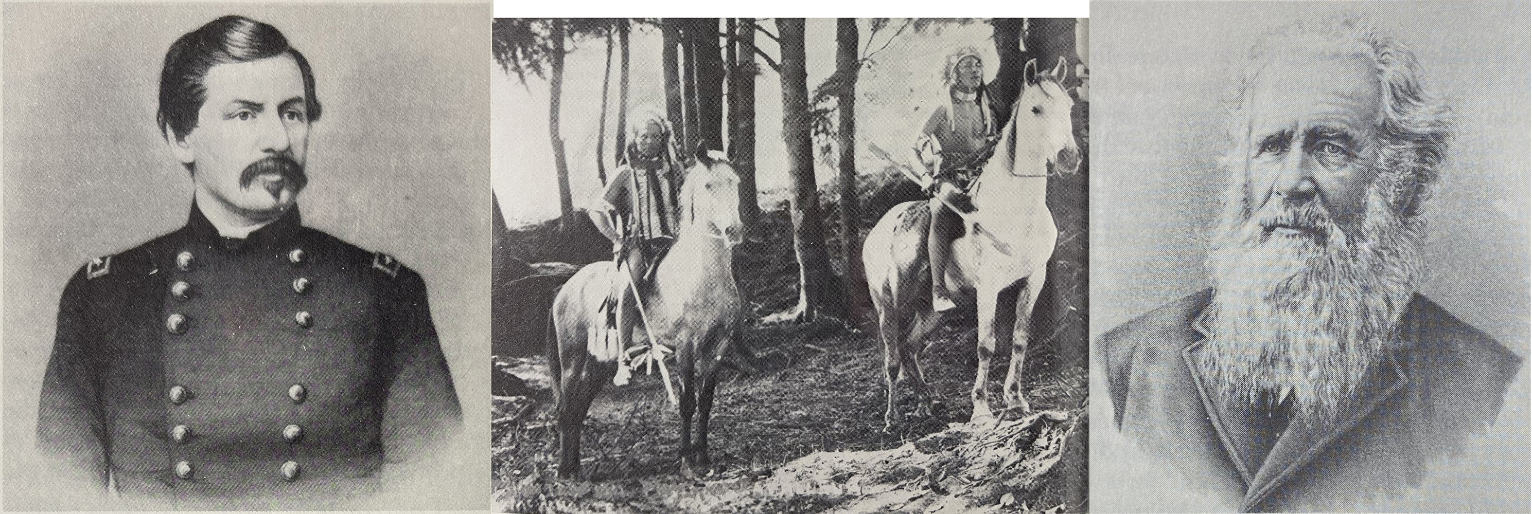
 Left: Captain George McClellan, Center: Two Yakama in ceremonial dress, Right: Major J.H.H. VanBokkelen
Major J.H.H. VanBokkelen
Finally, a government-backed expedition went over the true Snoqualmie Pass the summer of 1856 as a backpacking trip lead by Major VanBokkelen. When his party was camped at Snoqualmie Pass three Indians were spotted watching them. An unsuccessful pursuit of them followed. He reported that the Indian trail ended at the north end of Lake Keechelus, so he assumed the natives either continued by canoe or walked the shores when the water level was lower. He continued on the west bank of the lake with great difficulty but made it to the far end and beyond into the Yakima River valley where they saw Indian fish traps in the river, and Indian camps, but no Indians.
McClellan Butte, Abiel Peak, and Tinkham Peak
Two peaks and a road were named after Abiel Tinkham, another peak was named for McClellan. I am not aware of VanBokkelen’s name being applied to any landmarks.
When PCT hikers stop at Mirror Lake and gaze up at the peak behind it, they are looking at Tinkham Peak.
McClellan Butte is an unmistakable feature of the Cascades easily recognized from Seattle or Bellevue. It’s on the south side of Interstate 90 at Exit 42. A well-traveled trail leads to the spire at its summit. From there, forest roads can get you another 1 mile to Alice Lakes if you are adventurous.
The Road
In the 19th century, the US government only built roads for the military. Two years after VanBokkelen surveyed the pass the Indian war had ended and the military deprioritized a road over the Cascades, satisfied with using the Columbia River to access eastern Washington. A government-funded road across Snoqualmie Pass would not open for another 59 years, on July 1, 1915, two years after the creation of the Washington State Highway Department.
The story of the road over those 59 years is one of various interested parties, mostly merchants, constantly improving the road and clearing the inevitable annual damage each spring. Efforts were funded by donations, tolls, and a few state government grants. The Denny family of Seattle played amajor role in develoing the road. The road was heavily used by east side cattlemen driving herds to market on the west side, by miners entering the mountains from Seattle, and various other traders and travelers.
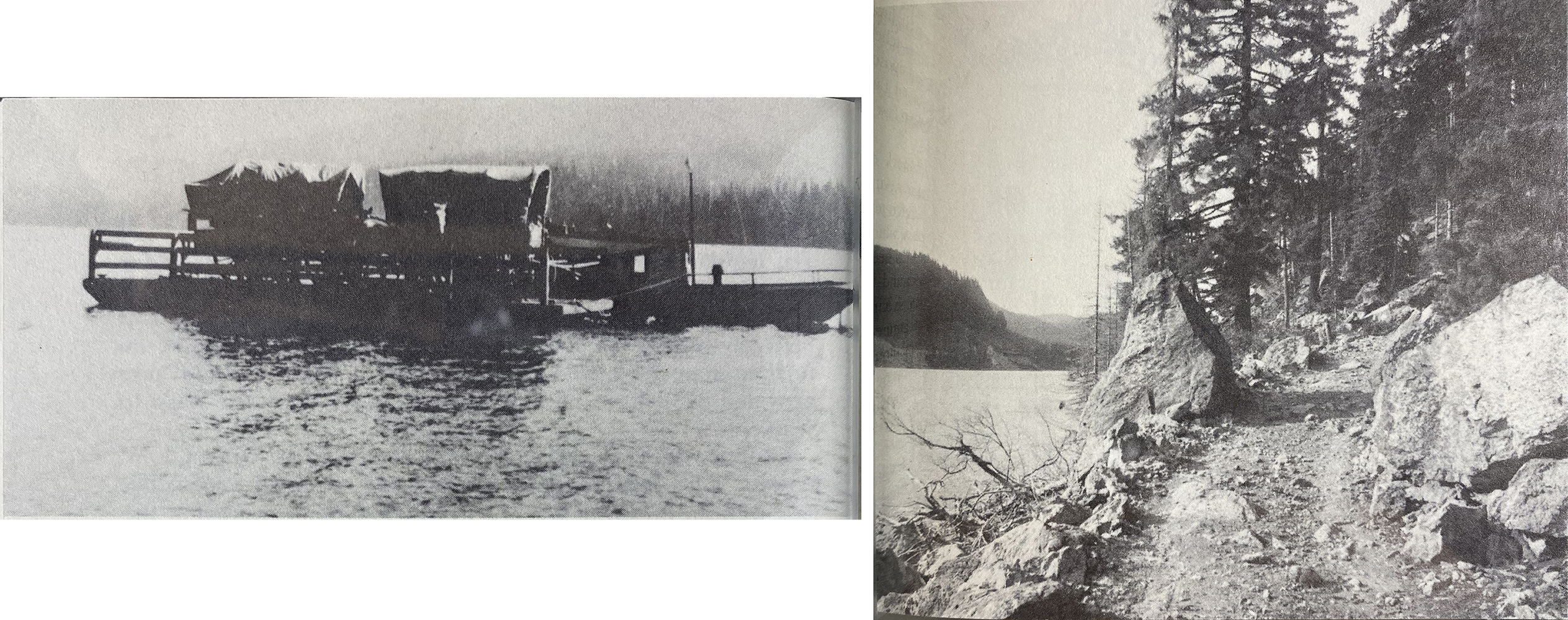
Getting wagons around Lake Keechelus continued to be the primary challenge to the route. When the water level was low enough wagons could follow the lake edge. But when the lake was high, a ferry was required to get wagons across. In 1912 Sidney Finch started a regular ferry service on the lake. Prior to that the Flanagan Lumber Company ran a ferry on an irregular basis.
 Left: Ferry on Lake Keechelus. Right: Wagon road along Lake Keechelus 1911.

Motorcars
The first motorized car to drive over the pass was driven by Bert Harrison in 1905. Unofficial records indicate 105 cars crossing in 1909.
The first woman recorded to have driven over Snoqualmie Pass was Clara Wasson in 1914. She was a widow and the first woman in Ellensburg to buy a car, a Ford. She'd only planned to drive to the pass and back to meet her sister and brother-in-law coming from Seattle, but she had to rescue them when the axle on their Buick broke. The next day she drove them from the pass all the way to Ballard. While she was staying in Ballard, a Seattle newspaper printed the story of another woman claiming to be the first, but her journey was four days after Clara's. Both ways Clara and her three children camped overnight at the pass sleeping on pine boughs. The state did not declare the road complete until the following year, 1915. She lived to be 102 years old and is buried in Thorp.
The first winter the pass was kept open was 1931-32. Avalanches along the route continue to be a problem. Concrete snowsheds over the road were added in 1950, recently replaced with a raised section of road that allows snow to flow underneath.
The road over the pass was paved by 1934. At that time, it followed the Denny Creek road. The 200 ft tall bridge over Denny Creek was completed in 1981 splitting the east and westbound lanes on opposite sides of the valley.
Northern Pacific Railroad
The NPR sent surveyors to Snoqualmie Pass in 1867. A year later the chief engineer announced that Snoqualmie Pass was the favored route for the railway. The NPR stationed two men at the pass during the winter of 1870-71 to record weather observations every 6 hours. Ultimately the railroad, built in 1887, did not go over Snoqualmie Pass. It comes from the east up the Yakima River, but three miles before Lake Keechelus it turns SE and plunges into a tunnel under Stampede Pass that was completed in 1888. PCT hikers are standing above the tunnel 1.1 trail miles south of the Stampede Pass Road crossing. There the overhead powerlines do not line up with the tunnel.
Milwaukee Railroad
The Milwaukee Railroad was the last railway built across the Cascades, the NPR line to Tacoma, and the Great Northern Railroad over Stevens Pass, having both been completed already. The MR was built west-to-east along the South Fork Snoqualmie River and crossed Snoqualmie Pass in 1909.
Today PCT hikers might stop at nearby Laconia Market. That building is the original Laconia train station. From 1909 to 1977 hikers and skiers simply took the train to the pass. In fact, the RR company started the ski resort in 1938 and owned it until 1950 after the lodge burned down. A detailed history of the Milwaukee Railroad at Laconia can be found here .
The Laconia stop was only used for 7 years because in 1915 the tunnel under the mountain, from Rockdale to Hyak, was completed shortening the route and eliminating much of the elevation gain. PCT hikers are standing above the tunnel 0.3 trail miles north of the Rockdale Creek crossing. The overhead power lines run directly over the tunnel.
Today the old Milwaukee RR grade is the Palouse To Cascades Trail, a 143 mile long multi-use trail which starts on the Columbia River at Beverly and ends at the town of Duvall, with just two short breaks in Ellensburg and North Bend.
The tunnel bypassing Snoqualmie Pass is a straight line from Rockdale for 2.2 miles, then makes a 45 degree turn south at the eastern Hyak end, which means no light at the end of the tunnel looking east. The tunnel is closed annualy for winter from Nov 1st to May 1st. There is only road access from the east end with parking at the old Hyak train station.
Lake Keechelus was first damned in 1906, and the dam was improved in 1914. In 1915 the road around the lake was completed.