This page covers snow melt history and trends for the PCT in Washington as well as other time-based factors for planning a hike in 2026. If you just want to know when its safe to leave snow gear at home when you hike the PCT, then you can follow the 2026 Trail Report.
Why avoid snow?
Some people avoid backpacking during the spring snow melt because the compact snow on the trail can be wet, slippery, and icy, because melting snow makes the trail and campsites muddy, because melting snow makes the streams high and crossings more difficult, because snow bridges become dangerous, and primarily because they do not want to carry crampons, microspikes, ice axes, or other snow gear. So I wrote this for people trying to determine when they can safely begin a hike without that gear. All the information here pertains only to the PCT within Washington state.
Preparing to encounter snow
It is impossible to guarantee that you will not encounter some snow on the PCT at any time. Blizzards in August have happened. This information is meant to be a good resource for general predictions of trail conditions. ultimately you are responsible for your own choices, preparations, and safety.
Personally speaking, If I'm going to leave any snow equipment at home it will be traction devices not arrest devices. If you have traction but no arrest, you are betting your life that you will not fall. If you have arrest but no traction, then you are planning to fall, but still be safe. When the snow is slushy neither traction nor arrest work well, but that still leads me to the same decision.
For hikers, I think the Black Diamond Carbon Whippet is the perfect arrest tool to carry, as opposed to an ice axe. I love this tool because its dual-function and you are more likely to have it in your hand when you need it. I was made aware of this tool by Ned Tibbits. (Normally I do not mention brand names, but only Black Diamond makes a Wippet.) In case you encounter unexpected snow and have only trekking poles, it's a good idea to learn and practice self-arrest using a trekking pole. It's not nearly as effective as an ice axe or whippet, but a good skill to have as a back-up.
Spring Planning and Predicting
Its folly to predict snow melt before the snow stops accumulating. That is typically by May 1st, but not always. The last snowfall of 2024 was June 16th, and in 2013 it was June 22nd. In 2001 the snow completely melted, then the next day it snowed 16 inches.
In the last thirty years, the latest melt was in 2011 when the trail was not clear until August 1st and the last snow accumulation was on July 2nd 2011. The next latest was in 2022 and 2002. There is no clear year-over-year trend. The trail is not emerging earlier each year as one might expect. It still seems quite random.
Snow Melt Variables
Elevation: Typically, lower elevations melt out before higher elevations, both because of relative snow depth and because of temperatures. Overall, the average elevation of the PCT increases as you move from south to north, with the exception of Goat Rocks.
Depth and Distribution: The distribution of snow along the trail, from north to south, is rarely even, and rarely correlates to elevation. That is mostly because of differences in the rain shadow between the Pacific Ocean and the trail. For example, Mount Baker and North Cascades National Park force moisture out of the air before clouds can get to Section L (high), yet nothing blocks saturated Pacific clouds from making it to Indian Heaven in the south (low). The variables of elevation and depth may counter each other. For example, in 2023 the snow was much deeper in the south and got consistently less deep moving to the north. The last part of the trail to melt in 2023 was near the Muddy River bridge, and that was two weeks after the northernmost section was melted out. 2024 had a similar snow distribution but less pronounced.
For 2026 the distribution of snow is typical in that its deeper in the south than the north, but that typical trend stops somewhere north of Stevens Pass and becomes atypical; Section L has especially deep snow this year relative to the rest of the trail in WA.
Topography: And of course, the snow always melts off southern slopes first, and northern slopes last, exposed areas first, and tree covered areas last. Every section of the PCT has some mix of those features.
Temperature On June 28th 2021 it was 108F at Snoqualmie Pass, 40 degrees above average. I watched the melt closely that year to see how much the heat accelerated it. I was surprised to see the melt speed up only slightly. What appears to speed up the melt is the daily low much more than the daily high. Cascade melts are very slow when it freezes every night. They speed up when the nights stay warm.
Step 1. Watch key snow depth sensors
There are weather stations near the PCT that have snow depth sensors and snow water equivalent sensors. These can be used to get a sense of snow depth, distribution (north-south), and melt rate. By May 1st current depths can be compared to historical data. That can offer a ball-park prediction of the melt rate. As sensors at lower elevations zero-out it helps narrow the prediction.
The higher elevation sensors worth watching are:
- Harts Pass (6,490 ft), mm 2625
- Green Valley (6,230), mm 2335
- Lyman Lake (5,980), mm 2555
- White Pass Upper (5,800), mm 2294
- Surprise Lakes (4,290), mm 2218
I pay the most attention to the last high-altitude sensor to zero out. That is typically Green Valley but may differ year to year.
This is merely step 1 because most of these sensors are on a southern slope and in full sun. So, even when all of them read zero, the trail is still mostly snow covered and it's still not safe to backpack without snow equipment.
Zero Day + 3 weeks
Zero day is when none of the sensors near the PCT detect any snow. On average, three weeks after zero day the entire PCT is snow-free enough to hike without any snow equipment. After zero day I start paying more attention to satellite imagery, reading trip reports on WTA.org, watching social media posts in hiking groups, and day hiking the PCT to see trail conditions for myself.
In 2024 Harts Pass zeroed on June 16th, Lyman Lake on June 25th, and Green Valley on July 1st. Then between July 15th and July 20th the trail went from about half covered in snow to almost entirely exposed. So like in the past five years, it took between two and three weeks after zero day.
In 2025 Harts Pass zeroed on June 5th, Lyman Lake on June 13th, and Green Valley June 17th.
In 2026 Harts Pass zeroed out on June 13th, Lyman Lake the day before, and Paradise two days later (Green Valley was out of order).
Typical Melt Order
If the snow distribution is fairly even, then the sections typically clear of snow in this order:
- Section I, North (Naches Pass to Snoqualmie Pass)
- Section H, South (Columbia River to Williams Mine, Indian Heaven (Trout Lake))
- Section K, North (Suiattle Bridge to Rainy Pass)
- Section L (Rainy Pass to Canada) In 2026 this was #8
- Section I, Mid (Chinook Pass to Naches Pass) In 2026 this was #3.
- Section I, South (White Pass to Chinook Pass)
- Section H, Mid (Mt Adams, Williams Mine to Midway)
- Section J (Snoqualmie Pass to Stevens Pass)
- Section K, South (Steven Pass to Suiattle Bridge, Glacier Peak)
- Section H, North (Midway to White Pass, Goat Rocks)
The time span from all sections having significant snow to none of them is about 3-4 weeks.
Old Snowy Mountain, Goat Rocks The high point of the PCT in WA (and, I would argue, Oregon) is on the NW slope of Old Snowy Mountain (7,200 ft). Before 2024 that patch of the PCT never emerged from the snow. Now it is the last patch to melt, shortly before the snows begin anew. However, the alternate high trail melts out relatively early (7,596 ft). So this spot has never been a blocking issue. Snow a mile north and a mile south of there is typically the blocker.
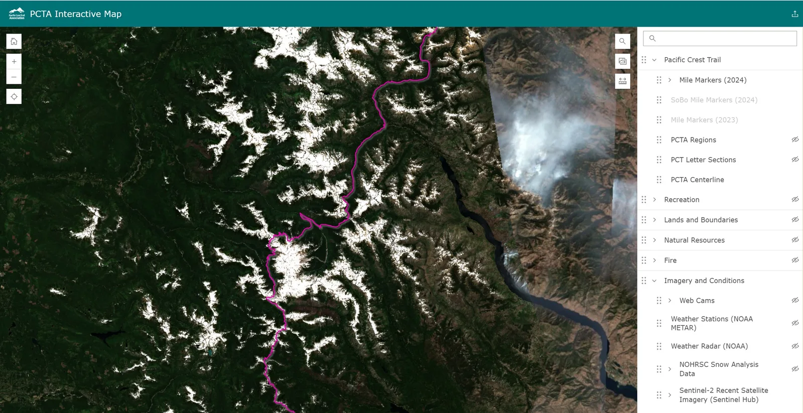
Step 2. Use Satellite Imagery
In 2023 the PCTA added many new image overlay options to its ArcGIS (geographic information system) map. Two of those overlays are useful for monitoring snow on the trail, the NOHRSC data, and the Sentinel-2 images. Both layers are listed in the Imagery and Conditions portion of the overlay menu in the right pane.
I have not found the NOHRSC imagery useful for evaluating trail conditions because it is too low resolution. One pixel is something like 75 acres. So, a given "pixel" color is often contrary to actual trail conditions there. It's more useful for seeing snow depth and distribution just before the melt begins.
The Sentinel-2 images can reveal exactly where there is snow on the trail If there is no cloud cover. The S2 satellite scans the PCT in WA every 5 days. If there is less then 30% cloud cover, then the images on the PCTA ArcGIS map update just as quickly as those one can retrieve directly from Sentinel-2. If there is more than 30% cloud cover, then I have to do some work to make the images useful.
Early start pros and cons
A great thing about getting on the trail early in the season is the long summer day. The summer solstice is on June 20th, offering hikers just under 16 hours of daylight from 5:08 AM to 9:06 PM. Unfortunately, the snow and slush typically do not melt off the PCT for weeks after the solstice. Another benefit of early season hiking is that water sources are abundant. A third benefit is warm nights. The bad thing about getting on the trail early is the emergence of mosquitoes when water has melted and daytime highs are hot. The mosquito population starts big and tapers off throughout the summer. Only the females drink blood. They become lethargic at 60F and they are unable to fly below 50F. The Indian Heaven area is famously thick with mosquitoes. However, bugs are on trail all summer long so they should not be a primary factor in planning the time of your hike. These pros and cons are reversed for late season hiking; fewer bugs, fewer water options, less daylight, cooler temps.
Fall Planning
Fall is a gorgeous time to hike in WA, especially after Labor Day when the crowds on the trail begin to thin out. The two issues most impacting backpacking in the fall are the dropping temperatures and the shortening days.
Fall Daylight
September 22 is the Autumnal Equinox. The daylight lasts for 12 hours and 9 minutes. The equinox is not when there is 12 hours of daylight. That is the equinox which occurs two days later on September 24th when the sun rises at 6:55 AM and sets at 6:55 PM.
Fall Temperatures and Snow
After the equinox is typically when the nights start freezing at 6,000 ft so I tend to switch to day hikes then. In 2024 snow dusted the cascades on October 17th, and again on 1Oct 20th, and by Oct 27th one inch had accumulated.
The first significant snowfall of the year occurred on:
- 2014 Oct 23th
- 2015 Oct 31st
- 2016 Oct 14th
- 2017 Oct 13th
- 2018 Sep 30th
- 2019 Sep 27th (then got colder fast)
- 2020 Sep 27th (Then got really hot for a few more days)
- 2021 Sep 29th
- 2022 Oct 24th (Oct 21 was the first night below freezing)
- 2023 Nov 11th (Nov 1st was the first night below freezing)
- 2024 Oct 27th (Sept 29 was the first night below freezing)
Note that in the fall there are typically multiple cycles of snow falling then completely melting, before it begins accumulating. Accumulation might not occur until very late in the year. Source: The Air & Water Datbase is maintained by the USDA, Natural Resources Concervation Service.
Other Factors to Consider When Timing Your Trip
Water sources
Some sections of the PCT have few year-round water sources (Chinook Pass to Naches Pass) so hiking in August and September may force you to carefully plan your water. Whereas hiking in July usually offers a bounty of seasonal water sources. Know all your water options before you go, both the reliable ones and the others. Because water is likely the heaviest thing in your pack, it's just good sense to manage your water economically.
Hot days
I covered cold nights above, but another temperture issue is hot days. A heat wave can occur anytime during the hiking season, so they are difficult to predict and avoid. Personally, I worry more about cold nights than hot days because I am willing split my hiking days to have a siesta when the heat peaks between 2:00 and 4:00 PM. I start hiking before sunrise, I cook my main meal during siesta, and I try to make camp close to sunset where I eat leftovers. I try to work swims into my schedule, and wet my hair and clothes at water sources, I like to wear a long sleeve shirt and wet the sleeves and collar. Some people even hike at night, which I like to do only when there is bright moonlight
The Sky (2025)
Sometimes I choose hiking dates based on the moon cycle or even meteors, comets, or eclipses. Night hiking in a full moon is one of my favorite things. You may want to factor these events into your planning. Here are some things to look for in the night sky this summer
Full Moons
- June 11 - Strawberry Moon
- July 10 - Buck Moon
- August 09 - Sturgeon Moon
- September 07 - Corn Moon
- October 06 - Harvest Moon
Meteor Showers
Meteor Showers occur when the earth passes through a debris field left by a comet or asteroid. The peak is when the earth is in the densest part of the debris field. Meteor showers are named for the star constellation they appear to radiate from. Here I've only listed showers that peak between June and October in the northern hemisphere.
2025 is going to be a fantastic year for meteor showers during hiking season because of three overlapping events.
- The Perseids will peak August 12th 2025 (span Jul 14-Sep 01). The Perseids come from the Swift-Tuttle Comet which is on a 133 year cycle. The last close encounter was 1992. The next will be 2125
- The Capricornids will peak July 30th 2025
- The Aquariids will peak on the same night July 30th 2025
People
Do you want to avoid other people? This is usually more of a where issue than a when issue, but here the WA PCT is a given. Some people seek solitude, some people feel more comfortable in numbers. These days the PCT is quite busy in peak season so solitude can be difficult in popular sections. You might choose to avoid the weekend day hikers who access the trail from paved roads by planning to cross those mid-week. The trail is popular with section hikers from the Independence day weekend to the Labor Day weekend. Then activity declines a bit through September. However, September is when many of the thru hikers are in Washington. It can be fun to hike the northern section, going southbound, in late September because you will pass many thru hikers as they finally close in on the Canadian border.
Events
Some people like to plan around events such as Pacific Crest Trail Days at Cascade Locks August 14 & 15th 2026.
Fire
Unfortunately, you cannot predict fires ahead of time. They tend to ruin plans at the last minute. In recent years fires have plagued the entire backpacking season, from before the snow melts to when it starts falling again. The best way to plan for fire is to know all your options for exiting the trail if needed. I also recommend you carry a mask to protect yourself from smoke and ash if needed. It's almost weightless and far better than a bandana or buff.
For section hikers I recommend hiking Section L as soon as possible because its most susceptible to fire.
Sentinel-2 History
This information is useful to me when too much cloud cover makes a satellite photo useless. I can do some math to select a historical photo that is most relevant.
In 2026 we got useful photos on:
- 2026 June 15th 65% clouds
- 2026 June 20th 5% clouds
- 2026 June 30th 40% clouds
- 2025 June 30th 1% clouds
- 2025 June 15th 1% clouds
- 2025 July 5th 36% clouds
- 2025 July 12th 10% clouds
- 2025 July 15th 1% clouds
- 2024 June 10th 8% clouds
- 2024 June 20th 30% clouds
- 2024 June 25th 1% clouds
- 2024 July 5th 1% clouds
- 2024 July 10th 1% clouds
- 2024 July 15th 1% clouds
Harts Pass Sensor zero day: - 2026 June 13th
- 2025 June 5th (2026 date -8)
- 2024 June 16th (2026 date +3)