2026 July 20th
This page or the entire website can be easily saved to your phone for offline viewing while on trail by following these instructions
Access Roads and Trails
Exit/entry to Section K is very limited this year. The current status of the major access roads and trails can be found here.
Creek crossings
The creek crossings are listed here and also on the Challenging Creek Crossings page. That page includes alternate routes if you choose not to cross as well as tips for how to cross.
Fires and Smoke
Most of the active fires listed here started in the July 15 lightning storm. Surface winds should stay easterly this week, so the east-side fires are likely a non-issue for PCT hikers. Air quality is OK now and should consistently improve this week to excellent thanks to those easterly surface winds. Please know how to get weather and fire information while on trail.
Blowdowns, blowdowns, and more blowdowns.
Anywhere trail crews have not yet reached will be littered with blowdowns because the soil was especially saturated this winter when storms hit. I've noted where trail crews have been to date.
Section L (Canada to Rainy Pass)
-
This section has no significant stream crossings.
-
Expect haze in Section L due to three nearby fires and smoke from fires in Canada. This will be true regardless of wind direction.
-
[mm 0] FIRE 9.8 miles west of the northern terminus - Border 1 (2 acres), Discovered 7/16
-
Many blowdowns between the Canada border and Castle Pass.
-
[mm 5] FIRE 6.5 miles east of Hopkins Pass - Ptarmigan (100 acres) Discovered 7/17. This fire is already on both sides of the Pasayten River.
-
[mm 7.5] There is a small singular patch of snow on Devils Staircase.
-
[mm 20] SMOKE from fire 21.5 miles west of Jim Peak - Luna (22 acres) Discovered 7/2.
-
[mm 36] Two small snow patches on the east slope of Syncline Mountain, between Tatie Peak and Grasshopper Pass.
-
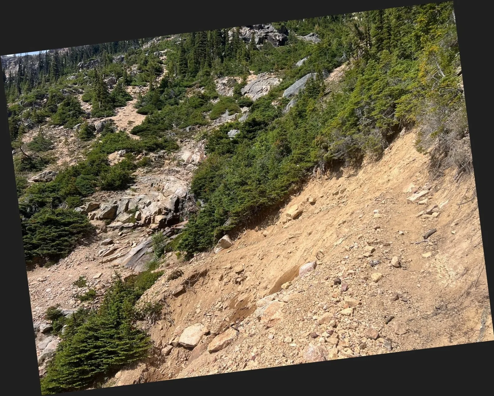
[mm 52.6] !Dangerous washout about 1/4 south of Methow Pass, under Tower Mountain. The North 350 Blades are aware, but I do not think they have assessed the damage yet. I suggest waiting for others hikers to witness your safe crossing. photo looking northbound.
-
[mm 53.7 - 56.5] Insignificant snow patches at Granite Pass and Cutthroat Pass.
Section K North (Rainy Pass to NF Sauk River)
-
There is no snow on the trail in this section.
-
As with past years, some aggressive bear activity has been reported in the NCNP portion of the PCT. These are only black bears.
-
North 350 Blades have been working this section and its clear of windfalls from Rainy Pass to well up into the Agnes Creek valley.
-
[mm 71] A temporary suspension bridge has been installed over Maple Creek.
-
Services in Stehekin are impacted by the December floods. Details are on the Resupply page.
-
[mm 93.25] The S. F. Agnes Creek Bridge at Hemlock Camp is out. A logjam should make for an easy crossing.
-
Expect hundreds and hundreds of blowdowns From Suiattle Pass to Milk Creek and still more after that.
-
[mm 103] Debris over trail from an avalanche below Plummer Mtn. just before crossing Miners Creek.
-
[mm 140] Kennedy Creek is rapid so cross with caution and with friends.
-
[mm 143.75] Baekos Bridge is still cracked in half but still in place and usable as a bridge.
Section K South (NF Sauk River to Stevens Pass)
-
Completely snow free.
-
[mm 153] Possible SMOKE from fire 11.5 miles east of Indian Pass - Little Giant (475 acres) Discovered 7/15. There are two rivers between this fire and the PCT.
-
[mm 181] FIRE 4.5 miles east of Union Gap Fire - Nason Ridge (5 acres) Discovered 7/16 This fire is already at the ridge of Nason Ridge.
-
Stevens Pass is open for summer operations.
Section J (Stevens Pass to Snoqualmie Pass)
-
Completely snow free.
-
Plan for a lot of windfalls in the north end of Section J.
-
[mm 193] Rockslide across trail just south of Lake Susan Jane (See N350 Blades assessment).
-
[mm 211.5] Folks still not loving crossing No Name Creek. A couple small logs seem to be helping.
-
[mm 224.5] Waptus River Bridge has washed away. There are multiple reports of a good log crossing downstream.
-
[mm 238.25] As usual since 2009, there is no bridge at Lemah Creek.
-
Crews have recently cleared windfalls from Lemah Creek to Park Lakes.
-
[mm 243.5] FIRE 2.8 miles south of Park Lake - Three Queens (30 acres) Discovered 7/15. The uphill vector for this fire is to the SE parallel to the PCT.
Section I, North (Snoqualmie Pass to Naches Pass)
- Clear of snow.
Section I, Mid (Naches Pass to Chinook Pass)
-
Clear of snow.
-
[mm 329] Possible SMOKE from fires east of Chinook Pass - Audubon (24 acres) and Sheep Company (141 acres)
Section I, South (Chinook Pass to White Pass)
- Clear of snow.
Section H, North (White Pass to Midway)
-
[mm 375.5] Old Snowy Mountain conditions are unknown due to cloud cover and not-great trail reports. Assume some snow, for about a mile. Typically hikers avoid late season snow by taking the high route.
-
No snow at all south of Old Snowy Mountain.
Section H, Mid (Midway to Williams Mine)
- Clear of snow.
Section H, South (Williams Mine to Columbia River)
- Clear of snow.
Why southbound mile marker numbers?
This report uses southbound mile marker numbers because by the time northbound hikers get to Washington the snow is melted and trail conditions are well known. The target audience is southbound thru hikers and section hikers. To view southbound mile markers in the FarOut app go to Settings and change the Trail Direction. This does not change the visual orientation of the trail, it just changes the mile marker numbers.